Popular Birding Destinations Maps
- Benton Lake NWR
- Bowdoin NWR
- Freezout Lake WMA
- Lee Metcalf NWR
- Ninepipe NWR
- Medicine Lake NWR
- Warm Springs Ponds
Cities with Multiple QQLL Divisions
Montana Bird Distribution Cooperators
Montana Bird Distribution QQLL Reference Maps
The birding community in Montana has historically collected data on bird distribution at a variety of scales based on Latitude and Longitude lines in the state -- originally in whole latitude and longitude blocks (LL), after the 3rd edition P.D. Skaar publication in quarter latitude and longitude blocks (QLL), and most recently in quarter-quarter latitude and longitude blocks (QQLL). The desire for more precise location information that can better be used to inform bird conservation has driven birders to collect data at a finer and finer spatial scale.
Using the QQLL Reference Map Download (upper right) or shortcuts in the table of contents (left) as a starting point you can download 8-1/2" x 11" PDF maps of specific QQLLs, popular birding destinations, and large cities in Montana as well as regional QQLL reference maps. These maps can then be printed out or saved to many mobile devices for reference in the field. To download overview maps of the QQLLs see the Travel Map Downloads (bottom right).
You may also want to check out the Generalized Observations task in MapViewer to filter by Species, Observation Types (B, b, t, W, w), and Dates. Then use the "Export to Excel" link to download that data.
Using the QQLL maps and data forms provided, observers may submit observations to the Montana Natural Heritage Program or Montana Audubon using a variety of reporting methods. Please see the links below for more information about how to submit observations.
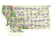
QQLL Reference Map Downloads
Click on the map image below to view the QQLL reference maps.
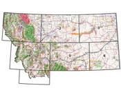
Travel Map Downloads
Click on the map image below to view the travel area maps.