
Latilong Numbering System in MontanaLatilongs are mapping units formed by successive lines of latitude and longitude, each at one degree intervals. These lines form a rectangular grid pattern across the state. Each latilong is assigned a number: 1 through 49 (See Figure Below). Latilongs 48 and 49 cover small portions of southwestern Montana. The average dimension of each latilong is 47 miles (76 km) wide and 69 miles (111 km) long, representing an average area of 3,200 square miles (8,4326 km). Latilongs along the Canadian border are 5.4 percent smaller than those along the Wyoming border. 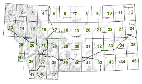
|
Quarter LatilongsQuarter latilongs are created by dividing each Latilong unit into four quarters (an area equivalent to that covered by sixteen 1:24,000 scale topographic maps). 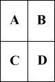
|
Quarter/Quarter LatilongsQuarter/quarter latilongs are created by dividing each Quarter Latilong into four quarters. This division creates an area equivalent to that covered by four 1:24,000 scale topographic maps.Example: LatiLong 1 divided by QLL and QQLL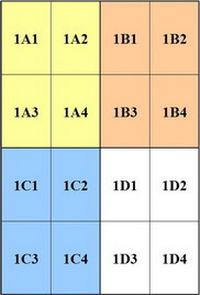
|
| Metadata | Download | View | Map Services | More Info | |
| Species Information | |||||
| Observations |
Animal  Plant
|
Request |
Snapshot MapViewer Field Guide |
- |

|
| SOC Species Occurrences |
Animal Plant
|
Request |
Snapshot MapViewer |
- | - |
| Animal Structured Surveys |
|
Request | MapViewer | - | - |
| Range Maps -- Animals | - | Request |
MapViewer Field Guide |
- | - |
| Predicted Suitable Habitat | - |

|
Predicted Models | - | - |
| Ecological Information | |||||
| Land Cover |
|
|
MapViewer |

|
- |
| Wetlands and Riparian Mapping |
|
|
MapViewer |
|
|
| Land Management Information | |||||
| Public Lands |
|
|
MapViewer | - |
|
| Conservation Easements |
|
|
MapViewer | - |
|
| Managed Areas |
|
|
MapViewer | - |
|
| Montana Geographic Information | |||||
| Montana Geographic Information |
|
|
- |
|
|
