


Community Field Guide
Scientific Name:
Calamovilfa longifolia - Carex inops ssp. heliophila Herbaceous Vegetation
Common Name:
Prairie sandreed - sun sedge Prairie
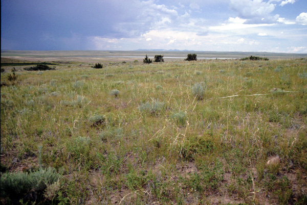
Photo by Peter Lesica
Community Description
Summary:
The prairie sandreed - sun sedge association occurs in the northern Great Plains states and probably extends well into Canada�s plains provinces (Coupland 1992). Stands occur on substrates with a significant component of sand, sandy loams or just sands, of colluvial or aeolian origin. This community tends to occur as small to large patches in gently rolling terrain. Calamovilfa longifolia dominates with a tall and open canopy of scattered mid-grasses and a highly discontinuous to sometimes thick mat of the short-graminoid and other diagnostic species such as Carex filifolia (threadleaf sedge). Other graminoids commonly present include Bouteloua gracilis (blue grama), Koeleria macrantha (prairie junegrass), Muhlenbergia cuspidata (plains muhly) and Hesperostipa comata (needle-and-thread). Pediomelum argophyllum (silver-leaved scurf-pea) and Dalea purpurea (purple prairie-clover) are the most common forbs, though their canopy cover tends to not exceed trace amounts. The only shrubs consistently present include Artemisia frigida (fringed sage) and Rosa arkansana (prairie rose), though their canopy cover seldom exceeds 5%. As with other sandy-soil communities, Selaginella densa (dense clubmoss) is sporadically present and expresses a fraction of the cover (usually less than 5%) that it exhibits on finer-textured soils.
Environment:
Stands are found on gently rolling uplands with little to moderate slope (typically between 0% and 20%, but occasionally as high as 39%) (Hirsch 1985, Hansen and Hoffman 1988). The soils are sand, sandy loam, or loamy sand and rarely have substantial soil horizon development (Hanson and Whitman 1938). The parent material is sandstone (USFS 1992). Moisture levels may be high and deep in the profile.
Vegetation:
The vegetation structure is somewhat open, with cover averaging 65% in parts of its range (USFS 1992). The vegetation is dominated by graminoids, with two strata, one of mid- to tall-grasses, the other of dense short sedges. In the taller grass layer, the most abundant species is Calamovilfa longifolia. Other species found in this layer include Koeleria macrantha, Schizachyrium scoparium, and Hesperostipa comata (= Stipa comata). Pascopyrum smithii may be present on some stands with finer soil textures. The short-graminoid layer is composed chiefly of Carex filifolia and Carex inops ssp. heliophila, which may have high cover values. Other upland Carices, such as Carex duriuscula (= Carex eleocharis), as well as Bouteloua gracilis and Muhlenbergia pungens, may also be present. Forb species diversity is moderate, but they do not contribute greatly to the cover (Hanson and Whitman 1938, USFS 1992). The forbs that are typical of this community include Artemisia dracunculus, Artemisia frigida (considered a shrub by some authors), Artemisia ludoviciana, Chenopodium album, Chenopodium leptophyllum, Lathyrus spp., Liatris punctata, Lygodesmia juncea, Phlox hoodii, and Psoralidium lanceolatum. Shrubs are uncommon. When shrubs are present they are short shrubs such as Yucca glauca, Rosa spp., and Artemisia frigida.
Range:
This prairie sandreed grassland is found in the northwestern Great Plains of the United States and Canada, ranging from the western Dakotas to Montana and Saskatchewan.
Global Rank: G3 State Rank: S3?
Global Rank Comments:
No occurrences have been documented, but the community is reported in 3 ecoregional subsections in Wyoming, Montana, North Dakota, South Dakota, and Saskatchewan. It is a very uncommon community in Badlands National Park, South Dakota.
Community References
Identifier:
CEGL001471
Author:
K. Hirsch; mod. J. Drake & D. Faber-Langendoen, MWCS; S. V. Cooper& C. Jean, MTNHP
Citations:
1992 Cooper et al., 2001, Hansen 1985, Hansen and Hoffman 1988, Hansen et al. 1984, Hanson and Whitman 1938
View Detailed Citation Information | New Community Search | NatureServe Explorer Community Information
This information is from the:
Montana Natural Heritage Program
Montana State Library--Natural Resource Information System
1515 East Sixth Ave., Helena, MT 59620-1800
406 444-3989
mtnhp.org
mtnhp@mt.gov
