


Community Field Guide
Scientific Name:
Shepherdia argentea Shrubland
Common Name:
Buffaloberry Shrubland
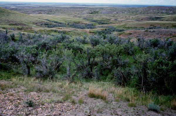
Photo by S.V. Cooper
Community Description
Summary:
This mesic buffaloberry shrubland community is found in the northern Great Plains of the United States and Canada. Stands occur on stream terraces, rolling uplands, and badlands, and where moisture is more plentiful than on the surrounding landscape, such as in swales, ravines, near streams, and on northwest- to east-facing slopes. The vegetation is dominated by a moderate to dense canopy of medium-tall shrubs. The most abundant of these, Shepherdia argentea, is typically 1.5-3 m tall. Other common shrub species are Juniperus horizontalis, Prunus virginiana, Ribes spp., Rhus aromatica, Rosa woodsii, and Symphoricarpos occidentalis. Graminoids and forbs may have only half the coverage of the shrub layer. Graminoids include Poa pratensis, Pascopyrum smithii, and Bromus spp. Common forbs are Achillea millefolium, Artemisia ludoviciana, and Parietaria pensylvanica. This community occurs in a predominantly prairie landscape as either narrow bands along streams or in small thickets.
Environment:
This community is found on stream terraces, rolling uplands, and badlands. It occurs where moisture is more plentiful than on the surrounding landscape, such as in swales, ravines, near streams, and on northwest- to east-facing slopes (Hansen and Hoffman 1988, DeVelice et al. 1995). This trend is more pronounced in Wyoming where Jones and Walford (1995) only found this community near streams, and it may be less pronounced in Saskatchewan and northern Montana. Soils are loamy sand, sandy loam, silty loam, or loam and are derived from glacial drift, siltstone, or sandstone (USFS 1992, DeVelice et al. 1995). This community does not flood often, but some sites show evidence of a high water table (DeVelice et al. 1995).
Vegetation:
The vegetation is dominated by a moderate- to dense-canopy of medium-tall shrubs. The most abundant of these, Shepherdia argentea, is typically 1.5-3 m tall. Other species commonly found in the shrub layer are Juniperus horizontalis, Prunus virginiana, Ribes spp., Rhus aromatica, Rosa woodsii, and Symphoricarpos occidentalis. Herbaceous species are not important in this community. Graminoids and forbs may have only half the coverage of the shrub layer (Hansen and Hoffman 1988, USFS 1992). Graminoids include Poa pratensis, Pascopyrum smithii, and Bromus spp. Common forbs are Achillea millefolium, Artemisia ludoviciana, and Parietaria pensylvanica. Litter may accumulate in this community (DeVelice et al. 1995).
Range:
This mesic buffaloberry shrubland community is found in the northern Great Plains of the United States and Canada, extending from Colorado northward to the Dakotas and Saskatchewan. This mesic shrubland community is found in the northern Great Plains on stream terraces, rolling uplands, and badlands.
Global Rank: G3G4 State Rank: S3?
Global Rank Comments:
The number of occurrences is unknown. The community is reported from Montana (where it is ranked S3?), Wyoming (?), Colorado (S1), Saskatchewan (S?), and possibly North Dakota (SP).
Community References
Identifier:
CEGL001128
Author:
J. Drake, WCS; mod. S. V. Cooper & C. Jean, MTNHP
Citations:
DeVelice et al. 1995, Cooper et al. 2001, Hansen et al. 1984, Hansen et al. 1991, Hansen et al. 1995, Jones and Walford 1995, Kittel and Lederer 1993, Kittel et al. 1994, Kittel et al. 1999, U.S. Forest Service (USFS) 1992
View Detailed Citation Information | New Community Search | NatureServe Explorer Community Information
This information is from the:
Montana Natural Heritage Program
Montana State Library--Natural Resource Information System
1515 East Sixth Ave., Helena, MT 59620-1800
406 444-3989
mtnhp.org
mtnhp@mt.gov
