


Community Field Guide
Scientific Name:
Artemisia tridentata ssp. wyomingensis / Elymus lanceolatus ssp. albicans Shrubland
Common Name:
Wyoming big sagebrush / thickspike wheatgrass Shrubland
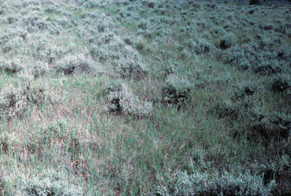
Photo by S.V. Cooper
Community Description
Summary:
This Wyoming big sagebrush community is found throughout the northern Great Plains and southward to northern Colorado, with considerable distribution gaps owing perhaps to lack of inventory. Stands occur as extensive matrix types on level to gently rolling plains, as well as small and large patches in dissected landscapes such as breaks and badlands. Soils are developed from various parent materials weathering to predominantly heavy-textured, clay-rich Aridisols, and in more mesic conditions, Mollisols. The vegetation is characterized by an open shrub layer dominated by Artemisia tridentata ssp. wyomingensis ranging in cover between 10% and 25%. Ericameria nauseosa (=Chrysothamnus nauseosus) and Artemisia frigida are consistently present in amounts less than 5%, unless the community has experienced abusive grazing. Elymus lanceolatus is conventionally the dominant and diagnostic graminoid, though in exceptionally mesic representations it may have less cover than Nassella viridula or Poa pratensis. Other important associated graminoids include Koeleria macrantha, Hesperostipa comata (=Stipa comata), Bouteloua gracilis and Carex filifolia. Total forb cover is low while the more constant species are Sphaeralcea coccinea, Vicia americana, Achillea millifolium and Opuntia polyacantha.
Environment:
Artemisia tridentata ssp. wyomingensis / Pascopyrum smithii is an extensive plant association in the western portion of the Northwestern Glaciated Plains but its coverage drops dramatically to the east, and in northern Valley and Phillips Counties coverages were only widely scattered, generally less than 5 acre stands. This association is typically found on gently rolling (slope inclination < 10%), till-mantled surfaces; it is also found in breaklands and on well-drained alluvial terraces. Others (Hansen and Hoffman 1988, Hansen et al. 1984, Tisdale and Hironaka 1981, Jorgensen 1979, Mackie 1970) have described this type as an edaphic or topoedaphic climax, associated with heavy soils in southeastern Montana or shallow, gravelly, or claypan surface soils in north-central Montana. Lacking adequate soils information we can only speculate, based on landscape position, that most of our sites represent edaphically controlled conditions. The amount of exposed substrate is generally considerably higher (average 50%, ranging to 80%) than for adjacent communities.
Vegetation: Graminoids with moderate- to high-constancy are Nassella viridula, Koeleria macrantha, Poa secunda, Carex filifolia (or Carex duriuscula) and Pseudoroegneria spicata. Of these, only Nassella viridula and Pseudoroegneria spicata were noted as occasional layer co-dominants or present with greater than 10% cover, but never the two in the same stand. Hesperostipa comata was well represented on sandier sites (sandy loams). Forbs are a minor component; those occurring with greater than 50% constancy are Sphaeralcea coccinea and Vicia americana.
This type (Artemisia tridentata spp. wyomingensis) is recognized by a well-represented shrub layer; usually its cover does not exceed 50%, averaging somewhere in the 20-35% range. No other shrubs with high constancy exist but Chrysothamnus nauseosus, Artemisia frigida and Gutierrezia sarothrae are regularly present with low coverages. Well-represented Elymus lanceolatus is diagnostic for the herbaceous layer, though intensively grazed areas may have lower coverages (average cover approximately 20%). Ease of livestock access makes these sites prone to overgrazing; none of the sampled sites were even close to pristine. Even in livestock exclosures weedy or invader species (e.g. Melilotus officinalis, Taraxacum officinalis, Bromus tectorum) are aggressively expanding (having gained a foothold prior to exclosure creation). Somewhat inexplicably, Selaginella densa (compact clubmoss) does not seem to increase on these sites the way it does on grassland sites, but it can occur with high cover values under unexplained circumstances.
Range:
This community has been described from Colorado northward through the Green River Basin and other basins of south- Central and northern Wyoming (Bighorn Basin) with a large gap in its documented distribution until it is documented from the Northern and Northwestern Glaciated Plains Sections of Montana.
Dynamics: Another portion of this association occurs on sideslopes and generally more mesic positions that can usually be recognized by the presence of Nassella viridula and Carex inops ssp. heliophila and higher coverages of Elymus lanceolatus. We speculate these stands should be considered a seral representation that ultimately will progress through a stage where Juniperus scopulorum is strongly represented to dominant. Pinus ponderosa may be an early seral component with Juniperus scopulorum or it may reinvade the stand later in the sere to ultimately dominate the overstory producing a Pinus ponderosa - Juniperus scopulorum / Carex inops ssp. heliophila association.
The vegetation and environment descriptions pertain to the potential natural vegetation expression of this association. Fire sweeping through these communities tends to completely consume the sagebrush, main stem and all, and even ostensibly, in the hottest of burns, dishes out the stem at ground level. The resulting community is described as the Pseudoroegneria spicata - Pascopyrum smithii (Elymus lanceolatus) association and Elymus lanceolatus and Pseudoroegneria spicata canopy cover approximates that of the pre-burn condition, though there may be an ephemeral fertilizer effect with more robust Pseudoroegneria spicata tussocks resulting. We found no Wyoming big sagebrush seedlings in any of the sites that had been sagebrush communities, nor anywhere at all in the study area, even in areas immediately adjacent to existing communities where Artemisia tridentata ssp. wyomingensis is a significant component. We found at least one area (burned prior to the Alkali Creek fire) having the potential to support Wyoming big sagebrush; this site had no evidence of returning to sagebrush prevalence. We speculate that succession in this type would take considerably longer than the 10-to 20- year span commonly cited. In Wyoming, Sturges (1984) stated that a similar Artemisia tridentata ssp. wyomingensis community had recovered to pre-treatment sagebrush cover in approximately 11 years following treatment of a complete watershed. However, Sturges obtained a very different result from test plots where complete control had been achieved. In test plots, sagebrush remained an �extremely minor� component 20 years following treatment. The explanation of these seemingly contradictory results is that much of the sagebrush surviving in the watershed treatment served as seed source points, whereas in the test plots there was complete eradication requiring seed to drift in from some distance. In the Snake River Plains a post-burn sere was shown to require at least 20 years to attain pre-burn sagebrush density (Harniss and Murray 1973). In southwestern Montana, Wambolt (2001) has also shown that fire in Wyoming big sagebrush is stand replacing, killing or removing most of the aboveground vegetation, and that recovery to pre-burn cover (of sagebrush) takes at least 20 years.
Global Rank: G4 State Rank: S4?
Community References
Identifier:
CEGL001044
Author:
WCS, mod. S.V. Cooper and C. Jean, MTNHP
Citations:
Cooper et al. 2001, Giese 1975, Gross 1955, Leucite Hills Mine Application n.d., Lundberg 1977, Marr et al. 1979, Steger 1970, Terwilliger et al. 1979a
View Detailed Citation Information | New Community Search | NatureServe Explorer Community Information
This information is from the:
Montana Natural Heritage Program
Montana State Library--Natural Resource Information System
1515 East Sixth Ave., Helena, MT 59620-1800
406 444-3989
mtnhp.org
mtnhp@mt.gov
