


Community Field Guide
Scientific Name:
Festuca idahoensis - Hesperostipa richardsonii Herbaceous Vegetation
Common Name:
Idaho fescue - Richardson's needlegrass Herbaceous Vegetation
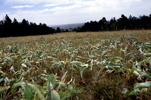
Photo by Cathie Jean
Community Description
Summary:
This montane grassland association occurs in scattered locations in the mountains of southwestern Montana and northern Wyoming on both sides of the Continental Divide. Stands are found infrequently on relatively mesic, gentle terrain with deep soils. Elevation ranges from 1100-2100 m. This association has a dense and diverse herbaceous layer dominated by medium-tall perennial graminoids with perennial forbs. Dominant graminoids are Achnatherum richardsonii (= Stipa richardsonii), Festuca idahoensis, Achnatherum occidentale (= Stipa occidentalis), and Danthonia intermedia. Perennial forbs are abundant and diverse. Consistent forbs are Geranium viscosissimum, Achillea millefolium, and Heterotheca villosa. Scattered Rosa arkansana shrubs are often present. The dominance of Stipa spp. and the lack of Pseudoroegneria spicata, Pascopyrum smithii, or Elymus caninus as a codominant species make this association distinct.
Environment:
Sites supporting this type are poorly documented in Montana. In southwestern Montana it occurs primarily in sheltered environments, such as toeslopes and leeward slopes in the foothills or lower slopes of mountain ranges, from 6,600 to 7,600 feet (there is no reason to suspect that this community is restricted to this elevation range). These are locations one would expect to receive drifted snow or possibly be subirrigated or in some way have augmented moisture regimes. The fact that sites are in collecting positions is borne out by the soils, which are loams or silt loams in texture and have virtually no rock in the upper 20-30 cm of the profile. Given the soil characteristics and landscape position of the type, we infer that soils are primarily aeolian in origin with some colluvial and slopewash fine materials added. Reflecting the highly productive nature of these sites, the substrate surface is composed of copious litter and just a trace of exposed soil. This community is very circumscribed in area, usually less than 2 to 3 acres, because it is apparently confined to small lenses of aeolian materials. Adjacent vegetation is almost invariably dominated by the more mesic plant associations within the Artemisia tridentata ssp. vaseyana and Festuca idahoensis alliances, usually those communities (or phases) denoted by Elymus trachycaulus, Stipa richardsonii, Geranium viscosissimum, Potentilla gracilis and Potentilla glandulosa.
Vegetation:
The shrub component is present as scattered individuals of Artemisia tridentata ssp. vaseyana and Ericameria nauseosa (=Chrysothamnus nauseosus) whose cover usually does not exceed trace amounts. Stands with plot data had a very strongly dominant tall graminoid layer that was so dense as to convey the look of an agricultural field when viewed from a distance (other stands, more open with less herbaceous cover, were noted in passing). Stipa richardsonii is conspicuously dominant with cover usually in excess of 70%. Other graminoids of high constancy include Festuca idahoensis, Elymus trachycaulus, Stipa occidentalis, Danthonia intermedia, and Pascopyrum smithii, their individual cover seldom exceeds 10 %. The suite of mesic site forbs regularly present includes Gentiana affinis, Potentilla gracilis, Geum triflorum, Cirsium scariosum (or Cirsium undulatum), Agoseris glauca, Campanula rotundifolia and Galium boreale; seldom does individual forb cover exceed 5% and combined forb cover is usually in the range of 5-15%.
Range:
This community is currently known from the foothills and lower slopes of the Snowcrest, Gravelly, and Blacktail Mountain Ranges and the hills and ridge complexes between these ranges. It has been documented to occur in Wyoming, well within the Southern Rocky Mountain Steppe - Open Woodland - Coniferous Forest - Alpine Meadow Province.
Global Rank: G3 State Rank: S3
Global Rank Comments:
This grassland association occurs in scattered locations in the mountains of southwestern Montana and in Yellowstone National Park is northwestern Wyoming. Stands are local and infrequent because they restricted to relatively uncommon topography and edaphic conditions, occurring on relatively mesic, gentle terrain with deep soils. The major threat is overgrazing by livestock because it can degrade the condition of these grasslands. More survey work is needed to determine the extent and condition of this association.
Community References
Identifier:
CEGL001625
Author:
99-11-22 / S. V. Cooper, MTNHP
Citations:
Bourgeron and Engelking 1994, Driscoll et al. 1984, Mueggler and Stewart 1980
View Detailed Citation Information | New Community Search | NatureServe Explorer Community Information
This information is from the:
Montana Natural Heritage Program
Montana State Library--Natural Resource Information System
1515 East Sixth Ave., Helena, MT 59620-1800
406 444-3989
mtnhp.org
mtnhp@mt.gov
