


Community Field Guide
Scientific Name:
Festuca idahoensis - Potentilla diversifolia Herbaceous Vegetation
Common Name:
Idaho fescue - mountain meadow cinquefoil Herbaceous Vegetation
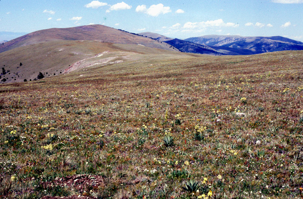
Photo by Jim Vanderhorst
Community Description
Summary:
This association is described from alpine slopes of the Pioneer and White Knob mountains of central Idaho and the Beaverhead, Gravelly, Snowcrest, and Tendoy ranges of western Montana. The association occurs at the lower margin of the alpine zone on moderately steep north-facing slopes. Stands range from 9500-10,080 feet. Soils are derived from granitic, limestone, and calcareous sandstone rocks. Winter snow accumulation is light to moderate and melts early in the growing season. Festuca idahoensis dominates the relatively lush meadow vegetation, and Potentilla diversifolia is codominant. Astragalus alpinus, Carex nova, Erigeron simplex, Phlox pulvinata, Poa cusickii ssp. epilis (= Poa epilis), Polemonium viscosum, and Solidago multiradiata frequently occur with moderate abundance. Deschampsia caespitosa is often present but occurs with low abundance. Subalpine forest or shrublands are adjacent in warm, dry downslope positions. Deschampsia caespitosa / Potentilla diversifolia is adjacent on more moist sites. Carex elynoides-dominated turf is adjacent on warm, dry upslope positions.
Environment:
The Festuca idahoensis / Potentilla diversifolia association is common below 9,900 feet in the Beaverhead, Gravelly, Snowcrest and Tendoy ranges. This type was most common on warm slopes at the low limit of alpine vegetation (about 9,500 feet) where moderate to light snow cover melts early in the growing season. It abutted subalpine forests dominated by Picea engelmannii, Pinus albicaulis and Pseudotsuga menziesii, or graded into shrublands dominated by Artemisia tridentata ssp. vaseyana below treeline. Festuca idahoensis / Potentilla diversifolia merged with Deschampsia caespitosa (=Deschampsia cespitosa) / Potentilla diversifolia grassland on moister slopes and with Carex elynoides turf at higher elevations on warm, dry, wind-impacted slopes. Dominance of Bromus pumpellianus defines a phase that was locally abundant on cool slopes in the Snowcrest Range.
Vegetation: In the Bromus pumpellianus phase, two stands from cool slopes in the Snowcrest range were dominated by Bromus pumpellianus instead of Festuca idahoensis. Carex obtusata was abundant in one. These stands were otherwise compositionally similar to typical Festuca idahoensis / Potentilla diversifolia.
Mean graminoid cover of Festuca idahoensis / Potentilla diversifolia was 55%. Festuca idahoensis was the dominant graminoid with Elymus trachycaulus ranking second in abundance. Carex obtusata, Poa secunda, Carex scirpoidea and Poa arctica were locally common, the former two on warm aspects and the latter two on cooler slopes or level areas with deeper soils. Mean forb cover was 34%. Common forbs were Potentilla diversifolia, Phlox pulvinata and Polemonium viscosum. Polygonum bistortoides, Myosotis sylvatica and Cerastium arvense were frequent, and Geum triflorum and Trifolium haydenii were locally common. Mean cover of lichens and mosses was only 2%.
Global Rank: G3 State Rank: S3
Global Rank Comments:
This regionally endemic plant association occurs in remote, high-elevation sites of southwestern Montana and central Idaho. The association occurs at the lower margin of the alpine zone on moderately steep north-facing slopes. Stands range from 10,080 to 9500 feet. Soils are derived from granitic, limestone, and calcareous sandstone rocks. Winter snow accumulation is light to moderate and melts early in the growing season. These isolated, specialized habitats are relatively well protected from the impacts of resource utilization such as intensive livestock grazing and recreational use. Known occurrences are ranked as being in good to excellent condition. Appropriate inventories to determine the rangewide condition of stands, however, have not been conducted. No protected occurrences have been reported.
Community References
Identifier:
CEGL001623
Author:
Edition / Author: 99
Citations:
Bourgeron and Engelking 1994, Caicco 1983, Cooper and Lesica 1992, Cooper et al. 1997, Driscoll et al. 1984, Moseley 1985
View Detailed Citation Information | New Community Search | NatureServe Explorer Community Information
This information is from the:
Montana Natural Heritage Program
Montana State Library--Natural Resource Information System
1515 East Sixth Ave., Helena, MT 59620-1800
406 444-3989
mtnhp.org
mtnhp@mt.gov
