


Community Field Guide
Scientific Name:
Artemisia cana / Hesperostipa comata Shrub Herbaceous Vegetation
Common Name:
Silver sagebrush / needle-and-thread Shrub Prairie
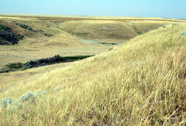
Photo by R. DeVelice
Community Description
Summary:
This prairie association, which generally occurs in small patches (less than one hectare), occurs in the northwestern Great Plains. In Montana, it is found on benches to gently inclined slopes (30% maximum recorded) in the vicinity of breaklands. Similar habitats (old river terraces, badlands, ravine sideslopes and valley walls) support its occurrence in Alberta. Sites occur on various parent materials, but mostly well-drained, often sandy, glacial drift and sandy alluvium. Artemisia cana is decidedly the dominant shrub with canopy coverage to 50%, but averaging around 25%, which places it on the cusp of being a true shrub type. Artemisia frigida is the only shrub/sub-shrub with greater than 50% constancy and its cover seldom exceeds 3%. A number of graminoids have high constancy including Bouteloua gracilis, Carex filifolia, Koeleria macrantha, and Poa secunda (= Poa sandbergii), but only Hesperostipa comata exhibits both 100% constancy and the highest cover values (averaging 38%). Forbs constitute an insignificant component, virtually none occurring in greater than trace amounts. Those exceeding 50% constancy are Sphaeralcea coccinea, Pediomelum argophyllum (= Pediomelum argophyllum), and Psoralea tenuiflora, Gaura coccinea. This association is hypothesized to represent the driest environment capable of supporting Artemisia cana. Occasional fire probably has reduced Artemisia spp. cover and density to low levels and maintains the shrub herbaceous community structure.
Environment:
It is found on benches to gently inclined slopes (30% maximum recorded value) of rolling prairie, steeper ravine slopes, and all manner of topography in the vicinity of breaklands. It occurs on various parent materials but mostly well-drained, often sandy, glacial drift. The ground cover is highly variable with some sites (putatively overgrazed) having a sward of Selaginella densa and lichens, while others have 70% litter and trace amounts of Selaginella densa; only one plot had as much as 10% exposed soil, gravel and rock (combined cover).
Vegetation:
Artemisia cana (probably Artemisia cana ssp. cana [Shultz 1984]) is decidedly the dominant shrub with canopy coverage ranging to 50% on heavily grazed sites, but averaging 27%; Artemisia frigida is the only sub-shrub with greater than 50% constancy and its cover did not exceed 3%. A number of graminoids have high constancy, Bouteloua gracilis, Carex filifolia, Koeleria macrantha, and Poa secunda (= Poa sandbergii), but only Hesperostipa comata exhibits both 100% constancy and the highest cover values (averaging 38%). Muhlenbergia cuspidata and Calamovilfa longifolia had inexplicably high cover on some sites. Forbs constitute an insignificant component, occurring in trace amounts; those exceeding 50% constancy are Sphaeralcea coccinea, Pediomelum argophyllum (= Pediomelum argophyllum) and Psoralea tenuiflora, Gaura coccinea. This association is hypothesized to represent the driest environment capable of supporting Artemisia cana. Most often this association grades to upland range sites dominated by Hesperostipa comata and Bouteloua gracilis and to the Artemisia cana / Pascopyrum smithii association that occupies more mesic positions on lower floodplain terraces.
Range:
This association is well documented from Montana and Alberta, Canada. The same or a closely analogous type occurs in Wyoming, and some permutation of the type is to be expected in northwestern North Dakota and Saskatchewan.
Global Rank: G3 State Rank: S3
Global Rank Comments:
This small patch type currently has a narrowly circumscribed geographic distribution, though it may be expected to occur in Saskatchewan and North Dakota. Habitats with the potential to support this type appear to be relatively abundant, but the type itself is comparatively uncommon. Though embedded in primarily agricultural landscapes, the proximity of this type to breaklands/badlands probably lessens the chances of its being sacrificed to the plow. This type's affinity for well drained benches and gently inclined landforms in a primarily agricultural landscape puts it at a moderate risk for agriculture conversion. Fortunately this landform also occurs in breakland and badland environments less desirable for agriculture, thus lessening the chances of this uncommon type being converted to agriculture. Its graminoid composition renders it only moderately attractive to cattle, and the scarcity of forbs decrease its value as sheep range.
Community References
Identifier:
CEGL001553
Author:
S.V. Cooper and C. Jean
Citations:
DeVelice et al. 1991, DeVelice et al. 1995, Thilenius et al. 1995
View Detailed Citation Information | New Community Search | NatureServe Explorer Community Information
This information is from the:
Montana Natural Heritage Program
Montana State Library--Natural Resource Information System
1515 East Sixth Ave., Helena, MT 59620-1800
406 444-3989
mtnhp.org
mtnhp@mt.gov
