


Community Field Guide
Scientific Name:
Sarcobatus vermiculatus / Pascopyrum smithii Shrub Herbaceous Vegetation
Common Name:
Black greasewood / western wheatgrass - (thickspike wheatgrass) Shrub Prairie
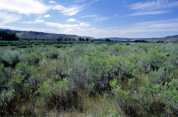
Photo by Bonnie Heidel
Community Description
Summary:
This greasewood shrub-prairie is found in saline habitats in the northwestern Great Plains of the United States and Canada. Stands occur on flat- to gently sloping alluvial fans, terraces, lakebeds, and floodplains. The soil is usually deep clay, silty clay, sandy clay, or loam, although coarse soils are possible. They are saline or alkaline, but salt crusts on the surface are typically absent. Parent material is usually alluvium. This community has moderate- to dense-vegetation cover. Medium-tall (0.5-1.5 m) shrubs are scattered throughout with a total shrub canopy of 10% to 25%. The shrub layer is dominated by Sarcobatus vermiculatus, with Artemisia tridentata, Atriplex confertifolia, and Chrysothamnus viscidiflorus in smaller amounts. Symphoricarpos occidentalis and Rhus aromatica are sometimes found in more mesic microhabitats within this community. Herbaceous cover is sparse beneath the shrubs and otherwise moderate to dense. The dominant species are typically 0.5-1 m tall. The most abundant species is Pascopyrum smithii, usually accompanied by Bouteloua gracilis, Bromus japonicus, Bromus tectorum, and Hesperostipa comata (=Stipa comata). Few forbs are found in this community. Achillea millefolium and Opuntia polyacantha are the only species with high constancy. Overall species diversity in this community is low.
Environment: Although this association occurs in small patches, these patches or linear arrays occur on adjacent ridge systems or are contiguous along footslopes or alluvial bottoms and are never far from one another, which then qualifies this as a matrix type, at least in the study area landscape. At the eastern edge of the study area this association occurs on footslopes and alluvial bottomlands on outwash materials derived from the rounded and eroded terrain immediately to the west and as part of the Musselshell River floodplains. However, it also extends to upland positions, namely ridge shoulders and upper slopes irrespective of aspect or steepness. It occurs only on particular ridge systems, ostensibly those having parent materials with a unique chemistry that would produce somewhat higher alkali salt concentrations (mostly sodium?). Soils are derived from shale and siltstone and exhibit primarily loams and silt loams for alluvial positions and silty clay and silty clay loam textures on uplands with no or little stone content in the upper 20 cm. Characteristically the upland stands have much exposed soil, in excess of 80%, and many erosional features including rills and soil creep.
This community is found on flat- to gently sloping alluvial fans, terraces, lakebeds, and floodplains (Mueggler and Stewart 1978, Hansen and Hoffman 1988). Dodd and Coupland (1966) found Sarcobatus vermiculatus in association with Pascopyrum smithii only on the most arid parts of southwestern Saskatchewan. The soil is usually deep clay, silty clay, sandy clay, or loam (Hirsch 1985, Jones and Walford 1995), although coarse soils are possible (USFS 1992, Thilenius et al. 1995). They are saline or alkaline, but salt crusts on the surface are absent (Thilenius et al. 1995, but see Steinauer and Rolfsmeier 1997). Parent material is usually alluvium. Flooding during the spring is possible.
Vegetation: In Alkali Creek, the diagnostic species are highly variable with Sarcobatus vermiculatus varying from approximately 3% to 20 % and Elymus lanceolatus ranging from 10% to 60 % plus. The higher canopy coverages (approaching 80% vegetative cover) are associated with the type as it occurs on downslope or outwash materials, and upper slope/ ridgeline examples have as little as 15% to 20% combined vegetative cover. The common shrub associates seldom exceeding 5% cover are Artemisia tridentata ssp. wyomingensis, Artemisia cana, and as a reflection of unusual soil conditions, Atriplex gardneri. Bouteloua gracilis and the alien annual Bromus japonicus are the only graminoids with greater than 50% constancy. The forb component is quite depauperate; except for the occasional patch of the introduced Melilotus officinalis contributing more than 5% cover. The four or five other forbs seldom exceed 1% to 3% combined cover.
This community has moderate- to dense-vegetation cover (Jones and Walford 1995, Thilenius et al. 1995). Medium-tall (0.5-1.5 m) shrubs are scattered throughout, with a total shrub canopy of 10% to 25% (Hansen and Hoffman 1988, USFS 1992). The shrub layer is dominated by Sarcobatus vermiculatus, with Atriplex confertifolia, Atriplex canescens, Atriplex argentea, Artemisia tridentata, and Chrysothamnus viscidiflorus in smaller amounts. Symphoricarpos occidentalis and Rhus aromatica are sometimes found in more mesic microhabitats within this community (Hirsch 1985). Herbaceous cover is sparse beneath the shrubs and moderate to dense in between. The dominant species are typically 0.5-1 m tall. The most abundant species is Pascopyrum smithii, usually accompanied by Bouteloua gracilis, Bromus japonicus, Bromus tectorum, and Hesperostipa comata. Few forbs are found in this community. Achillea millefolium and Opuntia polyacantha are the only species with high constancy. Other species present may include Grindelia squarrosa. Overall species diversity in this community is low (Hansen and Hoffman 1988, Von Loh et al. 1999). In Nebraska, shrub species cover may be very low, and saline pockets may contain Distichlis spicata and Sporobolus airoides. Astragalus bisulcatus may be prominent (Steinauer and Rolfsmeier 1999).
Dynamics:
Unlike the Artemisia component of this association, which is completely obliterated by fire, Sarcobatus was noted to resprout from its root crown, especially in the upslope stands where fuel loading would have been less than in the footslope communities having abundant fuels (and thus hotter burns). It is difficult to specify the graminoid fire response in any detail, but ostensibly the post-burn cover of Elymus lanceolatus is at least as great as that of the pre-burn (Wright and Bailey 1982). The post-burn communities appear almost indistinguishable from many stands of the Pseudoroegneria spicata - Pascopyrum smithii - (Elymus lanceolatus) or Elymus lanceolatus- Nassella viridula associations, except that Sarcobatus vermiculatus / Pascopyrum smithii - (Elymus lanceolatus) has on average, reduced grass cover, and Nassella viridula is not present. This association was notable for having some of the highest cover of Bromus japonicus, both unburned and especially as a post-burn response. Similarly high, Bromus japonicus cover was shown for this association in the work of Hansen and Hoffman (1988) and by Mueggler and Stewart (1977). The post-burn response for Alkali Creek area was inferred from the fact that observed unburned stands had Bromus japonicus cover values that never were as high as those of the burned stands. This is a weak inference; we did search extensively for paired stands (spatially proximal), burned and unburned, but the Alkali Creek Fire did not leave many upslope positions unburned. Only a pre-burn cover or biomass measurement followed by fire can supply the answer.
Global Rank: G4 State Rank: S4
Community References
Identifier:
CEGL001508
Author:
J. Drake, mod. 99-11-16 / S. V. Cooper, MTNHP
Citations:
Bourgeron and Engelking 1994, Brown 1971, Dodd and Coupland 1966, Driscoll et al. 1984, Earth Resource Technology n.d., Fisser et al. 1965, Hamner 1964, Hansen and Hoffman 1988, Hansen et al. 1984, Hirsch 1985, Johnston 1987, Jones and Walford 1995, MTNHP 1988, Mueggler and Stewart 1980, Olson and Gerhart 1982, Steinauer and Rolfsmeier 2000, Thilenius et al. 1995, USFS 1992, Von Loh et al. 1999
View Detailed Citation Information | New Community Search | NatureServe Explorer Community Information
This information is from the:
Montana Natural Heritage Program
Montana State Library--Natural Resource Information System
1515 East Sixth Ave., Helena, MT 59620-1800
406 444-3989
mtnhp.org
mtnhp@mt.gov
