


Community Field Guide
Scientific Name:
Artemisia cana / Pascopyrum smithii Shrubland
Common Name:
Silver sagebrush / western wheatgrass Shrubland
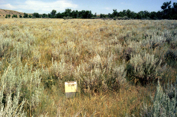
Photo by S.V. Cooper
Community Description
Summary: In the Bitter and Frenchman Creek study areas this type was noted to be scattered along most major drainages within the study area, fairly confined to streambanks and their immediate vicinity. Cattle heavily utilize these bottomlands and often the Pascopyrum smithii is heavily grazed. In these conditions Iva axillaris (poverty-weed) and Plantago patagonica (Indian-wheat) appear to be the increaser species.
The silver sagebrush - western wheatgrass shrubland is found mainly in the western Great Plains on flat alluvial deposits on floodplains, terraces or benches, and alluvial fans. The soils are moderately deep to deep and either silt loam, clay loam, or sandy loam. Flooding may occur periodically and this tends to retard soil development. This community is dominated by a combination of shrubs and graminoids. The total vegetation cover is moderate. The tallest and most conspicuous stratum in this community is a shrub layer that is usually 0.6-1.2 m. dominated by Artemisia cana. Grass cover is dominated by Pascopyrum smithii and typical forbs of this community are Achillea millefolium (yarrow) Psoralea tenuiflora, Gaura coccinea (scarlet gaura), Sphaeralcea coccinea (red globe-mallow), and Lactuca pulchella (blue lettuce).
Environment: The distribution of this community on the Alkali Creek study area is in accord with the general description for floodplains and lowest terraces. In Powder River County, this plant association is found on Overflow Ecological Sites in the 10-15 and 15-19 inch precipitation zones. It is the prevailing vegetation along major river valleys.
This community occurs on flat alluvial deposits on floodplains, terraces or benches, or alluvial fans. The soils are moderately deep to deep (USFS 1992) and either silt loam, clay loam, or sandy loam (Johnston 1987, Hansen and Hoffman 1988). The soils may have moderate salt content (Hanson and Whitman 1938). Flooding occurs periodically and this tends to retard soil profile development (Hirsch 1985).
Vegetation: Within the Alkali Creek study area, this community exhibits a distinctly shrub herbaceous habit with Artemisia cana cover often not exceeding 15%-20 % and total shrub cover (including Chrysothamnus nauseosus and Symphoricarpos occidentalis) exhibiting less than 25%. Pascopyrum smithii consistently dominates the undergrowth which is highly variable in cover, ranging from approximately 10% to 60%. Elymus lanceolatus is usually present as scattered patches and where a higher cover of Nassella viridula occurs it may be indicative of areas having escaped past grazing pressure. Very minor populations of Poa pratensis and Agropyron repens have been noted.
This community is dominated by a combination of shrubs and graminoids. The total vegetation cover is typically moderate, but depends on frequency of flooding. The tallest and most conspicuous stratum is a shrub layer that is usually 0.6-1.2 m (Hansen and Hoffman 1988). The USFS (1992) found that on 14 stands in western North Dakota, shrubs averaged 28% canopy cover, graminoids 59%, and forbs 2%. Stands in Nebraska often have less than 15% cover. The variation in soils within and between stands of this community results in variable species composition. Artemisia cana is the dominant shrub. Symphoricarpos occidentalis is frequently present. Shorter shrubs such as Artemisia frigida, Krascheninnikovia lanata, Rosa woodsii, and Gutierrezia sarothrae also occur. The most abundant graminoid is Pascopyrum smithii. This species is typically 0.5-1.0 m tall. It is often accompanied by Nassella viridula and sometimes Koeleria macrantha, Poa pratensis, and Stipa comata. Bouteloua gracilis is the most abundant short graminoid. Typical forb constituents of this community are Achillea millefolium, Psoralea tenuiflora, Gaura coccinea, Sphaeralcea coccinea, and Lactuca tatarica var. pulchella.
Range:
This silver or coaltown sagebrush shrubland is found in the northwestern Great Plains and Rocky Mountains of the western United States, ranging from Montana and North Dakota, south to Nebraska.
Dynamics:
Periodic flooding occurs in many stands of this community. Within the Alkali Creek Fire study area Artemisia cana was noted to have sprouted from root crown adventitious buds, but rhizome sprouting was not noted. The extent of Artemisia cana mortality could not be determined, however, burned and non- Sprouting stumps in drainage bottoms (expected Artemisia cana habitat) were judged not to be Sarcobatus vermiculatus and presumed not to be Artemisia tridentata spp. wyomingensis, but rather Artemisia cana.
Global Rank: G4 State Rank: S4
Community References
Identifier:
CEGL001072
Author:
Drake, J. F., WCS; Cooper, S. V. and C. Jean, MTNHP
Citations:
DeVelice et al. 1995, Hansen et al. 1984, Hansen et al. 1991, Hansen et al. 1995, Hanson and Whitman 1938, Hirsch 1985, Johnston 1987, Jorgensen 1979, Nelson 1961, Steinauer and Rolfsmeier 1997, U.S. Forest Service (USFS) 1992
View Detailed Citation Information | New Community Search | NatureServe Explorer Community Information
This information is from the:
Montana Natural Heritage Program
Montana State Library--Natural Resource Information System
1515 East Sixth Ave., Helena, MT 59620-1800
406 444-3989
mtnhp.org
mtnhp@mt.gov
